Murcia, a region located in southeast Spain, is a hidden gem for nature lovers and outdoor enthusiasts. With its diverse landscapes and scenic trails, it is the perfect destination for hiking. The province of Murcia has an infinite number of hiking routes that go through the spectacular natural landscapes of the province, thanks to the varied orography of its terrain and the combination of sea and mountains.
Here are 10 of the best hiking routes in the Murcia region:
This natural park is located in the Sierra de Espuna mountain range and covers an area of over 11,000 hectares. The park is home to a diverse range of flora and fauna, including Mediterranean forests, meadows, and a variety of bird species.
The Sierra Espuña Regional Park has 11 signposted trails, which are included in the Network of Trails of the Region, which make it possible to discover the most interesting enclaves and environments of the protected area. You will be able to see the most stunning views of the region!
In the municipality of Cieza, close to the province of Albacete border, the Almadenes canyon is a protected natural area. Follow the GR-127 signs that begin near the Almadenes hydroelectric power station if you want to explore this area on foot. The 8-kilometer walk takes roughly two and a half hours to complete.
You must cross a footbridge to get to the Mulata reservoir as the path borders the right bank of the Segura river, which created this area. This is a key point for those who are afraid of heights because it goes to a height of 70 meters. It is a circular route, so once you're done, you have to head back that way.
Additionally, you can visit the Serreta cave midway along the path, which contains more than 50 cave paintings from the Palaeolithic era, by making a reservation with the Cieza Town Hall.
Near the coast of Murcia, between Cabo de Palos and Portmán, is the Regional Park of Calblanque, Monte de las Cenizas, and Pea del guila. It is only about 9 kilometers away, can be accomplished in approximately 3 hours, and has only a small amount of incline.
You have to leave Punta de la Cruz and travel down a part of a Roman road before you can continue on the trail in order to learn more about this location. The ash batteries, a Civil War-era military installation, may be seen through the Mediterranean vegetation. You pass Punta Negra and Lastre beach on your way back to Punta de la Cruz.
This mountain range is located in the north of the Murcia region and is a popular destination for outdoor enthusiasts. The trails in Sierra del Puerto are well-marked and offer stunning views of the surrounding countryside, including the Mediterranean coast and the surrounding mountains.
One of Murcia's most picturesque locations is the Gebas ravine. To take the route that will allow you to get to know it, we advise hiring a guide or travelling with a GPS and good orientation because there are several trails that overlap and can cause mistakes. Additionally, because it is a desert region, it is not advised to visit when it is hotter than 25 degrees or when it has recently rained.
You'll enjoy breathtaking views of the beautiful azure reservoir, and sandy and rocky scenery. Also, if you like kayaking, you can safely try it by booking this excursion.
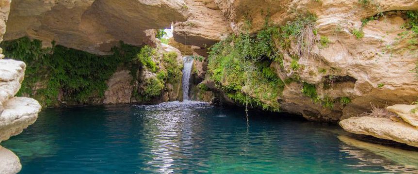
One of Murcia's most attractive towns, Bulas, is home to the Salto del Usero, a stunning location. There is a walkway that leads to the river Mula's environs, which are surrounded by a natural pool that the river has formed.
The same waterfall where you can take a bath is where this path begins. The route ascends to the summit of the hill for the best views of Bulla. It then descends the north face and makes its way back to the pool to rest. Although it is only nine kilometres, the elevation is a little challenging, so be ready and stay away from extremely hot days.
This mountain range is located in the southeast of the Murcia region, next to Abanilla village, and is known for its rolling hills and scenic trails. The trails in Sierra de La Pila are easy to follow and are suitable for hikers of all skill levels. In this area you can also find the Mahoya Desert, which has a fantastic lunar landscape.
One of Murcia's most picturesque communities, Caravaca de la Cruz, also has the Fuentes del Marqués nearby. This area's natural springs and up to four water springs that surround Arab dwellings at the base of the Gavilán mountain range give it its distinctive character.
Additionally, it is teeming with trees like the ash and pine trees typical of a riverfront forest.
Despite the fact that there are numerous routes through this region, one that is appropriate for kids begins in Caravaca de la Cruz and is about 6 kilometres long. It can be completed in about 2 hours and 45 minutes.
It occupies an area of 11,361 hectares and is situated west of Cartagena in the south of the Region. It consists of a number of headlands and mountain ranges along the coast that have steep slopes that descend to the water and are dotted with little bays. One of the best hiking trails to try, here you will find the beauty of the sea and the mountains. It is a setting with significant ecological and geomorphological importance and flora species that are unique to this region. Different raptors, including the Eagle Owl, Peregrine Falcon, and Bonelli's Eagle, nest on its rocky cliffs.
The buildings connected to human exploitation and usage on this land have been designated as Assets of Cultural Interest—windmills, defence towers, and military batteries. Here you will find the Castillitos Battery, also known as Battery C-1, is a coastal artillery fortification, declared an asset of cultural interest in 1997.
For surfers and swimmers in general, the Regional Park of Calblanque, Monte de las Cenizas, and Pea del Guila is a superb location. It is remarkable in that it is abundant with dunes, salt marshes, and other unique formations that may be found on its walks and in the Calblanque Visitor Center.
The trek starts here and proceeds to an ancient dune (which you can't walk on) and many viewpoint spots of the Calblanque salt flats. Following that, there are still mining extraction locations in the Reona cove.
Whether you're an experienced hiker or a beginner, the Murcia region offers a range of scenic trails to suit all skill levels. Murcia Dreams will help you to make a perfect decision for your next trip! So pack your hiking gear and get ready for an adventure in one of Spain's most beautiful regions!
If you want to discover more areas in the Murcia region, click here.
Contact our team if you have any questions.